


GROUNDWATER USE ZONING MAPPING USING GEOMORPHOLOGICAL APPROACH FOR HANDLING THE WATER CRISIS: STUDY CASE OF KECAMATAN PAGAK, KABUPATEN MALANG
(1) Universitas Negeri Malang
(2) Universitas Negeri Malang
(3) Universitas Negeri Malang
(4) Universitas Negeri Malang
(*) Corresponding Author
Abstract
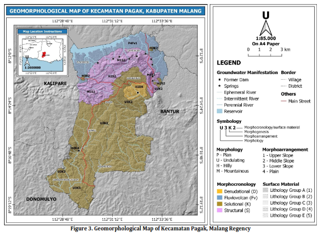
Kecamatan Pagak, Kabupaten Malang is an area which is dominated by karst landform. Basically, Karst is landform which is vulnerable to drought for the very minimum of waterflow surface. Â Underground river flows are more developed in karst landforms due to the large number of fractures. Based on these problems, this research seeks to solve the problem of water crisis in karst landforms by utilizing groundwater. It chose geomorphological approach to find the highly potential groundwater landforms so that these they can be used as groundwater infiltration zones. Geomorphological mapping is carried out by identifying aspects of morphology, morphogenesis, morphoarrangement, and morphocronology. Through the geomorphological mapping, it was obtained nine units of landforms in the research area. The P4Fv1 landforms are units that have high groundwater potential which can be utilized in large quantities.
Keywords
Full Text:
PDFReferences
Ahirwar, S., Malik, M. S., Ahirwar, R., & Shukla, J. P. (2020). Identification of suitable sites and structures for artificial groundwater recharge for sustainable groundwater resource development and management. Groundwater for Sustainable Development, 11. https://doi.org/10.1016/j.gsd.2020.100388
Ardakani, A. H. H., Shojaei, S., Siasar, H., & Ekhtesasi, M. R. (2020). Heuristic Evaluation of Groundwater in Arid Zones Using Remote Sensing and Geographic Information System. International Journal of Environmental Science and Technology, 17(2), 633–644. https://doi.org/10.1007/s13762-018-2104-1
Avtar, R., Singh, C. K., Shashtri, S., Singh, A., & Mukherjee, S. (2010). Identification and analysis of groundwater potential zones in Ken-Betwa river linking area using remote sensing and geographic information system. Geocarto International, 25(5), 379–396. https://doi.org/10.1080/10106041003731318
Bollollo, T. M., & Perilli, N. (2018). Integrating Remote Sensing and GIS Techniques with Conventional Methods to Assess and Characterize Surface and Groundwater Resources of Tendaho Graben, Ethiopia. International Journal of Geosciences, 09(05), 272–288. https://doi.org/10.4236/ijg.2018.95017
Cahyadi, A., Marfai, M. A., Nucifera, F., & Rahmadana, A. D. W. (2012). Perencanaan Penggunaan Lahan di Kawasan Karst berbasis Analisis Kemampuan Lahan dan Pemetaan Kwasan Lindug Sumberdaya Air: Studi Kasus di Kecamatan Ponjong, Kabupaten Gunungkidul, D. I. Yogyakarta. Seminar Nasional Science, Engineering and Technology, 23—24 Februari 2012. doi: 10.31227/osf.io/6b49a.
Djorfi, S., Beloulou, L., Djidel, M., & Guechi, S. (2018). Hydrochemical Evolution of Groundwater in the Tamlouka Plain, Influence of Lithology, Geomorphology and Anthropogenic Actions (pp. 685–687). https://doi.org/10.1007/978-3-319-70548-4_203
Eltarabily, M. G. A., & Negm, A. M. (2019). Groundwater management for sustainable development east of the nile delta aquifer. In Handbook of Environmental Chemistry (Vol. 73, pp. 687–708). Springer Verlag. https://doi.org/10.1007/698_2017_102
Fajarwati, F. 2 Oktober 2019. Kekeringan, 11 Desa Kekeringan Air Bersih. radarmalang.id. Dari https://radarmalang.id/kekeringan-11-desa-krisis-air-bersih/, diakses 18 Oktober 2019.
Faruq, D. U. A. 12 Juli 2019. 25.581 Warga Kabupaten Malang Terancam Kesulitan Air. Medcom.id. Dari https://www.medcom.id/nasional/ daerah/yNL7doWK-25-581-warga-kabupaten-malang-terancam-kesulitan-air, diakses 18 Oktober 2019.
Ford, D. & Williams, P. (2007). Karst Hydrogeology and Geomorphology. West Sussex: John Wiley & Sons Ltd.
Frisbee, M. D., Tysor, E. H., Stewart-Maddox, N. S., Tsinnajinnie, L. M., Wilson, J. L., Granger, D. E., & Newman, B. D. (2016). Is there a geomorphic expression of interbasin groundwater flow in watersheds? Interactions between interbasin groundwater flow, springs, streams, and geomorphology. Geophysical Research Letters, 43(3), 1158–1165. https://doi.org/10.1002/2015GL067082
Gebrie, T., Gadissa, E., Ahmad, I., Dar, M. A., Teka, A. H., Tolosa, A. T., … Fenta, A. (2018). Groundwater resources evaluation using geospatial technology. Environmental Geosciences, 25(1), 25–35. https://doi.org/10.1306/eg.01241817010
Groves, C., & Meiman, J. (2005). Weathering, geomorphic work, and karst landscape evolution in the Cave City groundwater basin, Mammoth Cave, Kentucky. Geomorphology, 67(1-2 SPEC. ISS.), 115–126. https://doi.org/10.1016/j.geomorph.2004.07.008
Indhulekha, K., Mondal, K. C., & Jhariya, D. C. (2019). Groundwater prospect mapping using remote sensing, GIS and resistivity survey techniques in Chhokra Nala Raipur district, Chhattisgarh, India. Journal of Water Supply: Research and Technology - AQUA, 68(7), 595–606. https://doi.org/10.2166/aqua.2019.159
Kantor Menteri Negara Lingkungan Hidup. (1999). Kawasan Kars di Indonesia: Potensi dan Pengelolaan Lingkungannya. Jakarta: Kementerian Negara Linkungan Hidup.
Kolli, M. K., Opp, C., & Groll, M. (2020). Mapping of Potential Groundwater Recharge Zones in the Kolleru Lake Catchment, India, by Using Remote Sensing and GIS Techniques. Natural Resources, 11(03), 127–145. https://doi.org/10.4236/nr.2020.113008
Kudamnya, E. A., Edet, A. E., & Ekwere, A. S. (2019). Geomorphological Control on Groundwater Occurrence Within the Basement Terrain of Keffi Area, North-Central Nigeria (pp. 257–259). https://doi.org/10.1007/978-3-030-01572-5_62
Lewin, J. & Woodward, J. (2009). Karst Geomorphology and Environmental Change. Dalam J. Woodward (Ed.). The Physical Geography of the Mediterranean. Oxford: Oxford University Press.
Malik, M. I., Bhat, M. S., & Najar, S. A. (2016). Remote Sensing and GIS based groundwater potential mapping for sustainable water resource management of Lidder catchment in Kashmir Valley, India. Journal of the Geological Society of India, 87(6), 716–726. https://doi.org/10.1007/s12594-016-0444-3
Mishra, D., & Singh, B. N. (2019). Identification of Groundwater Prospect in Bara Region of Allahabad District Based on Hydro-Geomorphological Analysis Using Satellite Imagery. Journal of the Indian Society of Remote Sensing, 47(7), 1257–1273. https://doi.org/10.1007/s12524-019-00984-w
Msaddek, M. H., Souissi, D., Moumni, Y., Chenini, I., Bouaziz, N., & Dlala, M. (2019). Groundwater potentiality assessment in an arid zone using a statistical approach and multi-criteria evaluation, southwestern Tunisia. Geological Quarterly, 63(1), 3–15. https://doi.org/10.7306/gq.1451
Muniraj, K., Jesudhas, C. J., & Chinnasamy, A. (2019). Delineating the Groundwater Potential Zone in Tirunelveli Taluk, South Tamil Nadu, India, Using Remote Sensing, Geographical Information System (GIS) and Analytic Hierarchy Process (AHP) Techniques. Proceedings of the National Academy of Sciences India Section A - Physical Sciences. https://doi.org/10.1007/s40010-019-00608-5
Nag, S. K., & Chowdhury, P. (2019). Decipherment of potential zones for groundwater occurrence: a study in Khatra Block, Bankura District, West Bengal, using geospatial techniques. Environmental Earth Sciences, 78(2). https://doi.org/10.1007/s12665-018-8034-x
Nigate, F., Camp, M. V., Yenehun, A., Belay, A. S., & Walraevens, K. (2020). Recharge-discharge relations of groundwater in volcanic terrain of semi-humid tropical highlands of Ethiopia: The case of infranz springs, in the upper blue nile. Water (Switzerland), 12(3). https://doi.org/10.3390/w12030853
Nigussie, W., Hailu, B. T., & Azagegn, T. (2019). Mapping of groundwater potential zones using sentinel satellites (−1 SAR and -2A MSI) images and analytical hierarchy process in Ketar watershed, Main Ethiopian Rift. Journal of African Earth Sciences, 160. https://doi.org/10.1016/j.jafrearsci.2019.103632
Nila R. P., Gangadharan, R., Ravichandran, P., Mahalakshmi, P., Panigrahi, A., & Pillai, S. M. (2015). Assessment of impact of shrimp farming on coastal groundwater using Geographical Information System based Analytical Hierarchy Process. Aquaculture. Elsevier. https://doi.org/10.1016/j.aquaculture.2015.06.025
Obiajulu, O. O., Okpoko, E. I., & Mgbemena, C. O. (2016). Application of Vertical Electrical Sounding to Estimate Aquifer Characteristics of Ihliala and Its Environs, Anembra State, Nigeria. ARPN Journal of Earth Sciences, 5(1), 13â»19.
Paat. 24 Oktober 2018. MUSDES Desa Sempol Kecamatan Pagak. Komando Distrik Militer 0818. Dari https://kodim-0818.id/musdes-desa-sempol-kecamatan-pagak/, diakses pada 18 Oktober 2019.
Pande, C. B., Khadri, S. F. R., Moharir, K. N., & Patode, R. S. (2018). Assessment of groundwater potential zonation of Mahesh River basin Akola and Buldhana districts, Maharashtra, India using remote sensing and GIS techniques. Sustainable Water Resources Management, 4(4), 965–979. https://doi.org/10.1007/s40899-017-0193-5
Pande, C. B., Moharir, K. N., Singh, S. K., & Varade, A. M. (2020). An integrated approach to delineate the groundwater potential zones in Devdari watershed area of Akola district, Maharashtra, Central India. Environment, Development and Sustainability, 22(5), 4867–4887. https://doi.org/10.1007/s10668-019-00409-1
Paul, R. S., Rawat, U., SenGupta, D., Biswas, A., Tripathi, S., & Ghosh, P. (2020). Assessment of groundwater potential zones using multi-criteria evaluation technique of Paisuni River Basin from the combined state of Uttar Pradesh and Madhya Pradesh, India. Environmental Earth Sciences, 79(13). https://doi.org/10.1007/s12665-020-09091-3
Poi, N., & Samanta, S. (2019). GIS, remote sensing and MCE approach for identifying groundwater prospective zones in mountainous region of PNG. Applied Geomatics, 11(3), 317–330. https://doi.org/10.1007/s12518-019-00259-6
Rachmi, I. N. (2018). Karakteristik Airtanah (Geohidrologi) Karst: Kajian dan Studi Literatur berbagai Mata Air dan Sungai Bawah Tanah Daerah Istimewa Yogyakarta. INA-Rxiv. doi: 10.31227/osf.io/y7c2v
Rajaveni, S. P., Brindha, K., & Elango, L. (2017). Geological and geomorphological controls on groundwater occurrence in a hard rock region. Applied Water Science, 7(3), 1377–1389. https://doi.org/10.1007/s13201-015-0327-6
Rehman, H. U., Ahmad, Z., Ashraf, A., & Ali, S. S. (2019). Predicting groundwater potential zones in Upper Thal Doab, Indus Basin through integrated use of RS and GIS techniques and groundwater flow modeling. Arabian Journal of Geosciences, 12(20). https://doi.org/10.1007/s12517-019-4783-4
Santosa, L.W. & Tjahyo, N.A. (2014). Karakteristik Akuifer dan Potensi Airtanah Graben Bantul. Yogyakarta: Gadjah Mada University Press.
Setiawan, T. (2015). Sistem Aliran Airtanah Akuifer Kars Fakfak, Papua Barat, berdasarkan Karakter Kelurusan dan Hidrogeokimia. Junral Lingkungan dan Bencana Geoglogi, 6(1), 31—44.
Sugiyanta, I. G. (2017). Geomorfologi. Yogyakarta: Mobius.
Srivastava, P. K., & Bhattacharya, A. K. (2006). Groundwater assessment through an integrated approach using remote sensing, GIS and resistivity techniques: A case study from a hard rock terrain. International Journal of Remote Sensing, 27(20), 4599–4620. https://doi.org/10.1080/01431160600554983
Teixeira, J., Chaminé, H. I., Carvalho, J. M., Pérez-Alberti, A., & Rocha, F. (2013). Hydrogeomorphological mapping as a tool in groundwater exploration. Journal of Maps, 9(2), 263–273. https://doi.org/10.1080/17445647.2013.776506
Verstappen, H. Th. 1983. Applied Geomorphology (Geomorphological Surveys for Enviromental Development). Amsterdam. Elsevier: Science Publisher.
DOI: https://doi.org/10.31327/gsej.v2i1.1311
Article Metrics
Abstract view : 997 timesPDF - 482 times
Refbacks
- There are currently no refbacks.
E-ISSN : 2716-4837 P-ISSN: 2723-6560
.png)
.png)
INDEXED BY:


This journal is published by the USN Scientific Journal Publisher
Universitas Sembilanbelas November Kolaka
Jalan Pemuda No. 339, 93517 Kolaka, Southeast Sulawesi, Indonesia
Copyright © 2020 USN Scientific Journal (USNSJ)

Except where otherwise noted, Geographica: Science and Education Journal (GSEJ) is licensed under a Creative Commons Attribution-NonCommercial 4.0 International License.